 PlaceTube
Northshore Road, Lake Mead National Park, Nevada Part 1
Open in PlaceTube Watch on YouTube
Places in this video
- Valley of Fire State Park East Entrance ▶ 0:08
The presenter starts at the east entrance of Valley of Fire State Park, with Elephant Rock and the Muddy Mountains visible in the background.
- Elephant Rock ▶ 0:45
The presenter points out the Elephant Rock area in the background behind the Valley of Fire east entrance sign.
- Muddy Mountains Wilderness ▶ 0:53
The presenter describes the Muddy Mountains Wilderness as a huge area a third the size of Rhode Island, and later views it from several angles along North Shore Road.
- Lake Mead National Recreation Area ▶ 1:20
The presenter plans to drive around the Overton Arm of Lake Mead to get an overview of the park, noting it has few trails but a prominent water trail.
- Overton Arm ▶ 1:43
The presenter repeatedly points out the Overton Arm of Lake Mead, the portion of the lake the drive skirts along North Shore Road.
- North Shore Road ▶ 1:47
The presenter takes North Shore Road all the way around the Overton Arm of Lake Mead toward the park entrance and Hoover Dam.
- Arrowhead Trail ▶ 3:06
The presenter notes the direction of the old Arrowhead Trail, which continues about 350 miles toward Salt Lake City.
- Virgin Mountains ▶ 3:22
The presenter identifies the Virgin Mountains and Virgin Peak in the distance, looking into Arizona from the high points along the drive.
- Stewart's Point ▶ 9:43
The presenter turns off North Shore Road at mile 41.5 and runs down an unpaved road to Stewart's Point, a campground on the Overton Arm with a 15-day camping limit and a possible kayak launch.
- Jimbilnan Wilderness ▶ 11:40
The presenter spots an untouched wilderness area toward Hoover Dam, later identifying it as the Jimbilnan Wilderness.
- Blue Spring ▶ 16:08
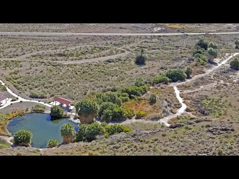
The presenter visits Blue Spring, an oasis with palm trees and reeds right off North Shore Road, and notes it as a parking and access point to the Muddy Mountains.
- Rogers Spring ▶ 20:28
The presenter explores Rogers Spring at mile 40, a desert oasis with a pond, fish, and palm trees, fed by an aquifer at 400 gallons a minute and 80 degrees year-round.
- Echo Bay ▶ 34:21
The presenter drives down Echo Bay Road from mile 35 to Echo Bay, where there are boat launches, camping, an abandoned hotel, and a fish cleaner.
- Pinto Valley Wilderness ▶ 35:02
The presenter points out the Pinto Valley Wilderness in the distance from the Echo Bay Road intersection and again from Echo Bay.
- Bowl of Fire ▶ 41:58
The presenter looks for and later gets a closer look at the Bowl of Fire on the southeastern edge of the Muddy Mountains Wilderness near mile 20.
- Redstone ▶ 46:05
The presenter stops at an area called Redstone around mile 25, with beautiful Aztec red frozen sandstone dunes 150 to 200 million years old.
- North Shore Summit Trail ▶ 50:42
The presenter runs up the quarter-mile North Shore Summit Trail to a peak with views of Lake Mead, the Bowl of Fire, and the Muddy Mountains Wilderness.