 PlaceTube
Hiking the Gunnison Route at Black Canyon of the Gunnison National Park (+ Overlooks!)
Open in PlaceTube Watch on YouTube
Places in this video
- Black Canyon of the Gunnison National Park Visitor Center ▶ 0:48
They head to the visitor center to try to get a free wilderness permit for the Gunnison Route, which is given out first come, first served starting 1.5 hours before closing.
- Gunnison Route ▶ 3:15
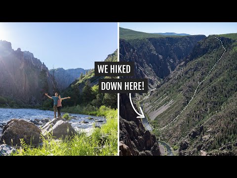
An intense, unmaintained route that drops 1,800 feet in a mile from the Oak Flat Loop down to the Gunnison River, requiring a permit limited to 15 people per day.
- Oak Flat Loop Trail ▶ 3:17
The Gunnison Route starts on the Oak Flat Loop Trail before splitting off onto the steep route down to the river.
- Gunnison River ▶ 10:06
They reach the river at the bottom of the canyon, where the water drops an average of 43 feet per mile, six times more than the Colorado River in the Grand Canyon.
- South Rim Scenic Drive ▶ 14:32
A seven-mile scenic drive on the more popular south rim with 12 overlooks; they drive it and stop at a handful of the best viewpoints.
- Pulpit Rock Overlook ▶ 15:36
From this overlook they get a good view of the Gunnison Route they just descended and where they had lunch by the water.
- Painted Wall Overlook ▶ 16:52
They view the Painted Wall, Colorado's tallest cliff at 2,300 feet, with 3D stripes in the rock face.
- Airbnb in Delta ▶ 17:34
They stay at an Airbnb in Delta, about 45 minutes from the park, so their dog Kona has a cool, safe place while they hike.
- North Rim Scenic Drive ▶ 19:42
The more remote north rim has a smaller scenic drive with only five overlooks, reached via a well-maintained dirt road.
- The Narrows Overlook ▶ 19:57
The first north rim overlook, showing a much narrower part of the canyon with sheer, jagged, striped walls.
- Exclamation Point ▶ 21:43
They hike a three-mile round-trip, mostly level trail to Exclamation Point, which offers a narrow straight shot through the canyon with the river roaring below.