 PlaceTube
Bhaskargad's Ancient Rock-Cut Steps | Phani Dongar & Utwad | Full Hiking Guide | EST Stage 03
Manav ·
Open in PlaceTube Watch on YouTube
Places in this video
- Tanke Harsh ▶ 3:09
The stage starts from this village; the trail out of Tanke Harsh towards Sinhasan Dongar is well used and in the morning you cross paths with locals collecting firewood.
- Sinhasan Dongar ▶ 3:25
The trail contours along the west-facing slopes of Sinhasan Dongar, meaning 'throne hill', with good shade but blind turns where you should make your presence felt.
- Harihar ▶ 3:56
At the saddle between Harihar and Sinhasan Dongar you see the south-facing rock face of Harihar, which looks completely different from the regular view.
- Ridge-line eateries near Harshewadi and Nirgudpada ▶ 4:12
Locals from Harshewadi and Nirgudpada open these eateries on the ridge only on weekends; on weekdays the shutters stay down, so refill water here on weekends.
- Phani Dongar ▶ 4:45
The EST climbs Phani Dongar, a steep ascent with a small rock patch before the rocky knob summit; its name comes from 'fani', a serpent's hood, which is what the hill looks like. The descent west is the trickiest part of the day, with steep scree and a rock patch to downclimb.
- Wayside shrine at the road saddle ▶ 7:29
After the Phani Dongar descent the trail drops onto a small road saddle with a wayside shrine, a few rocks marked with sindoor, on a road that sees almost zero traffic.
- Bhaskargad Fort ▶ 7:49
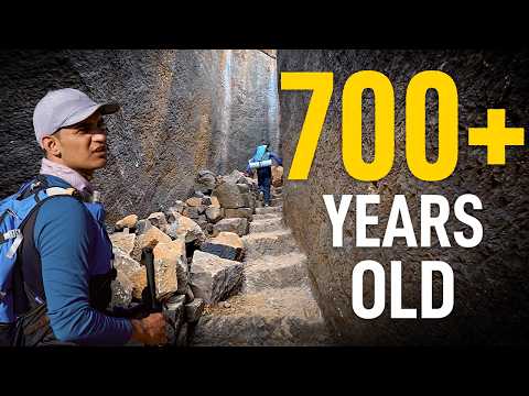
The trail climbs through forest and meadows to the base of the Bhaskargad rock face, then up rock-cut steps flanked by 10-12 ft gravel ramparts to the top, where there are stone-cut water cisterns (not potable).
- Bhaskargad Cave ▶ 8:41
A huge cave at the base of Bhaskargad's west face that works as a rain and night shelter for around 10 people, with a Shivling carved into the rock and a small drip of water inside.
- Mulichi Dhar ▶ 11:41
A thin descent ridgeline ('dhar' means ridgeline) that turns west towards Konkan; it is a ghatvaat connecting the people around Bhaskargad fort with Sirsonpada below, and has no water since ridgelines act as watersheds.
- Sirsonpada ▶ 11:41
The small hamlet at the base of the Mulichi Dhar descent where you refill water, the first water source since leaving Tanke Harsh.
- Dhangarwadi north of Khoch reservoir ▶ 13:35
A small isolated Dhangar settlement just north of Khoch reservoir, with a small but perennial drinking water source sitting in what looks like a dry riverbed.
- Khoch Reservoir ▶ 13:53
The trail runs along the west bank of the Khoch reservoir, where the presenter met a local 'trail angel' who guided him for two hours up towards Belkhanda Dhar.
- Bhatkala Dhar Ghatvaat ▶ 14:42
The more commonly used ridgeline route from the Khoch reservoir area up to the crestline, not steep with just one rock patch, contouring through Karvi plants to Khoch Khind.
- Khoch Khind ▶ 14:59
The saddle between Utwad and Bhaskargad where the ridgeline route reaches the crestline; the side trail to Utwad splits north from here.
- Govhkyachi Khand ▶ 15:14
A saddle south of Bhaskargad cave that connects the trail to the village of Dehelewali, where this stage ends.
- Dehelewali ▶ 15:14
The village where stage three of the Epic Sahyadri Trail ends, reached by dropping down to the Govhkyachi Khand saddle.
- Jarvad Khurd ▶ 15:31
The unmapped bailout from the saddle between Harihar and Sinhasan Dongar drops down to this village; it is not on the official map and needs local confirmation.
- Utwad ▶ 15:48
The highest mountain of the Trimbak range, reached by a side trail from Khoch Khind through Karvi plants to a rock face; villagers climb it barefoot to a shrine at the top, and the presenter found the rock climb easier without shoes.